Uíge Province
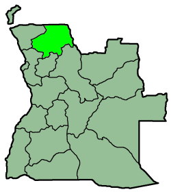
Uíge is a province of Angola. It has an area of 58,698 km² and a population of approximately 800,000. Uige is the capital of the province. Municipalities in this province include Zombo, Quimbele, Damba, Mucaba, Bungu, Macocola, Bembe, Buengas, Sanza Pombo, Alto Cauale, Puri, Negage, Quitexe, Ambuila and Songo.
Its primary agricultural products include coffee, beans, cassava, grain, peanuts, cotton, and wood. Important mineralogical resources include copper, silver, and cobalt.
Uige Province was one of the hardest-hit areas of Angola during the 26-year long civil war. Large segments of the population were displaced, and the infrastructure is severely damaged.
Beginning in October 2004 and continuing into 2005, Uige Province was the center of an outbreak of Marburg hemorrhagic fever, a disease closely related to Ebola. Now thought to be under control, it was the world's worst epidemic of any kind of hemorrhagic fever.
| This Angola location article is a stub. You can help Wikipedia by expanding it. |
|
|||||||